
Industry and governments face the increasingly difficult challenges of coupling the development of business and societal activities with the preservation of the natural world while meeting national and international climate targets. Additionally, the policies attempting to meet biodiversity protection and climate targets can only rely on limited budgets and must face and adapt to rapidly changing conditions (land use, regional climate, resource demand). With the information revolution and digitalization, available biodiversity and environmental data have been increasing exponentially in recent years. However, these data are not currently used to their full potential in the development of spatial planning policies aimed at concerted development and fulfillment of environmental targets.
Spatial planning tools allow the processing of various datasets to fulfil different area management objectives. The possibility of integrating biodiversity and environmental datasets allows for developing specific spatial planning tools that help to optimize different metrics. There are different spatial planning tools specifically designed for conservation area prioritization, such as Marxan, but all available tools lack technical features to provide optimal solutions.
To solve this problem, researchers from Sweden, the UK, and Switzerland have developed a spatial planning tool (CAPTAIN) specially designed for area prioritization using all available data. CAPTAIN is based on artificial intelligence (AI) and implements reinforcement learning algorithms to achieve optimal results. CAPTAIN has proven to outperform competing tools, like Marxan, in 97% of the cases.
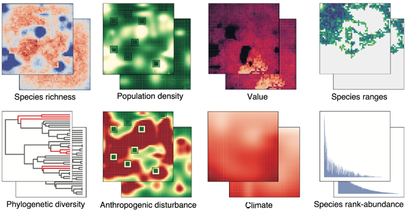
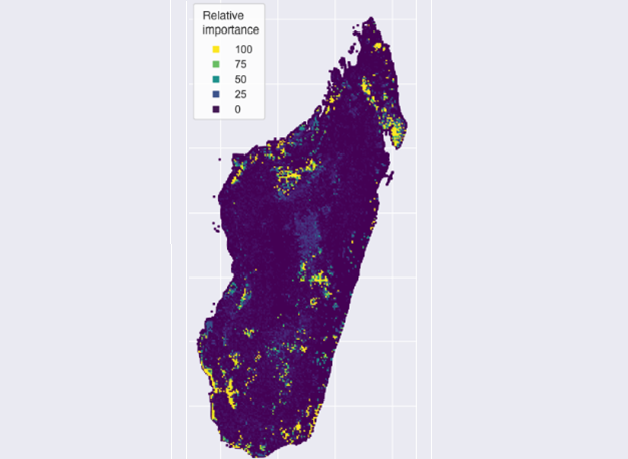
Example of input data used in conservation prioritization tests
Different tests have been performed to compare CAPTAIN performance with the state-of-the-art approach for conservation planning, Marxan, showing that CAPTAIN strongly outperforms it. With 1,500 species to protect based on a defined biodiversity target and using the same initial budget, CAPTAIN allowed to fully meet the target, while Marxan was unable to adequately protect 200 species.
Benefits:
- Area conservation and biodiversity CAPTAIN consistently outperforms competing solutions, like Marxan.
- It uses multi-dimensional input data and accounts for a dynamic environment
- It uses cutting-edge artificial intelligence and reinforcement learning methodologies.
- It can be implemented in existing suites and combined with other commercial software.
- The tool is very flexible and allows to optimize decision making for many applications that require spatial area planning:
• Area conservation and biodiversity protection. • Environmental impact evaluation, helping to decide where to develop new infrastructure, etc. • Carbon uptake, optimizing carbon offsetting activities. • Restoration potential, identifying areas for natural or aided restoration (including reforestation) with the highest potential gains in biodiversity and carbon benefits.
The represented institution is looking for a collaboration that leads to commercial exploitation of the presented invention.
Institution: Gothenburg University
TRL: 7-8
Protection status: Know-how
Contact: Pablo Lago / pablo@viromii.com